This is our second high altitude attempt with a small payload.
| Flight Parameters | |
|---|---|
| Launch Date/Time | Saturday, 1 October at 7:30am |
| Alternative Date | Sunday, 2 October at 7:30am |
| Launch Site | Wells Aircraft at the Hutchinson Airport (38° 03.8', 97° 51.9'W) in Hutchinson, KS |
| Primary Transmitter / Antenna | PocketTracker running APRS (W0WR-11) on 144.39MHz / Horizontally polarized dipole |
| Backup Transmitter / Antenna | PocketTracker running APRS (AJ0NR-11) on 144.34MHz / Horizontally polarized dipole |
| Balloon / Gas | Kaymont 1500gram / 110 cu feet of Helium |
| Estimated Burst Altitude | 120,000' MSL |
| Estimated Ascent Rate | 800' per minute |
| Estimated Descent Rate | Approx. 1000' per minute at touchdown |
| Capsule(s) weight | 1lbs 10oz including parachute, rigging, batteries, etc... |
| Chase Frequencies | 446.52MHz |
| Balloon Finder Telemetry Mode | N/a |
Flight Predictions
| Flight Predictions | ||||||
|---|---|---|---|---|---|---|
| Date Created (Central Time) | Dist From Launch | Bearing From Launch | Relative Position | Max Speed | Map | Winds |
| 26 Sep 8:30pm | 47mi | 19° (N-NE) | 2mi N. of Assaria | 49mph | Map | Winds |
| 28 Sep 12:00pm | 62mi | 7° (N) | 5mi NW of Salina | 53mph | Map | Winds |
| 29 Sep 11:45am | 47mi | 7° (N) | 4mi E-SE of Brookville | 41mph | Map | Winds |
Flight Results
111,083 feet MSL put us in the record books, but no where close to our goal. Two major factors contributed to this: First we swapped out one of the PocketTrackers with our standard controller board/HT. The second and related fact was that we slightly overfilled the balloon because of the extra couple of ounces.
| Flight Statistics | |
|---|---|
| Launch Date/Time | Saturday, 1 October 2005 at 8:48am. |
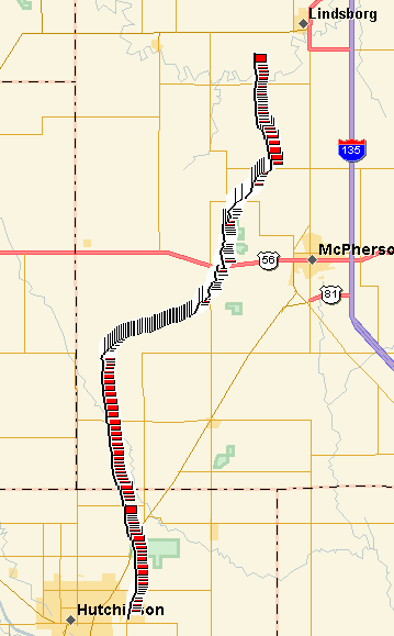
| Launch Site | Wells Aircraft at the Hutchinson Airport (38° 03.8', 97° 51.9'W) in Hutchinson, KS |
| Burst Altitude | About 111,083' (33,858m) MSL |
| Average Ascent Rate | 966 feet per minute (4.91m/s) |
| Measured Descent Rate | 1488 feet per minute (7.56m/s) |
| Touchdown Site | 3 miles southwest of Lindsborg, KS (38° 32.1524'N, 97° 43.6066'W) |
| Touchdown Time | Saturday, 1 October 2005 at 11:07am |
| Recovery Time | Saturday, 1 October 2005 at 12:15pm |
| Distance Traveled | 34 miles (54km) as the crow flies |
| Total Flight Time | 2 hours 19 minutes |
| Downloads | Lat/Lon File, Log File, Flight Analysis |

Lessons Learned
- Having transmitters on separate frequencies is a hassle to trouble shoot during a chase. On the other hand, it is comforting to have them on different channels in case of a stuck transmitter of excessive traffic.
- To check inflation, we need to have a loop attached to the neck of the balloon for the water jug to quickly attach to.